OBSERVATION WELL & BUILDING FOUNDATION INFORMATION
BGwT Observation Well Roadway Box
Welcome to the observation well and building foundation information center for the Boston Groundwater Trust. After reading the information below and agreeing to the terms, you will be taken to the center.
Observation Well Data
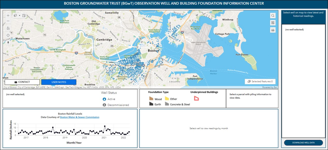
You can access data for a particular observation well by zooming in on the map or by entering a specific address for the area you are interested in. When you see the well that you want information for, click on it. The readings for the wells will appear on the right side of the screen, along a Download Data button to export all of the data for that particular well into an Excel sheet format. We have data for all active wells and historical data for decommissioned wells.
Observation Well Data
You can access data for a particular observation well by zooming in on the map or by entering a specific address for the area you are interested in. When you see the well that you want information for, click on it. The readings for the wells will appear on the right side of the screen, along a Download Data button to export all of the data for that particular well into an Excel sheet format. We have data for all active wells and historical data for decommissioned wells.
Groundwater and Pile Cutoff Elevations
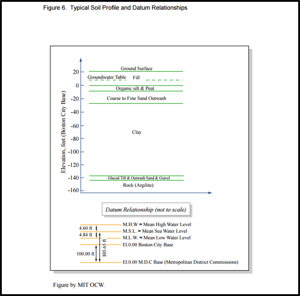
The groundwater elevations are referenced to Boston City Base Datum (BCB) as indicated in the graphic below and were measured by the Trust’s field engineers in each observation well on the dates indicated. Boston City Base is mean low tide level which is elevation 5.65' BCB. For reference, the Charles River is typically maintained between elevation 7.5' and elevation 8.0' BCB. While much of the information the Trust has compiled in reference to wood pile cutoff elevations are at elevation 5' BCB there are buildings where that number is higher and lower.
The groundwater elevations are referenced to Boston City Base Datum (BCB) as indicated in the graphic below and were measured by the Trust’s field engineers in each observation well on the dates indicated. Boston City Base is mean low tide level which is elevation 5.65' BCB. For reference, the Charles River is typically maintained between elevation 7.5' and elevation 8.0' BCB. While much of the information the Trust has compiled in reference to wood pile cutoff elevations are at elevation 5' BCB there are buildings where that number is higher and lower.
CLICK TO ENLARGE
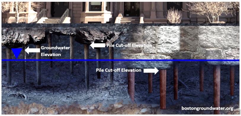
While the observation well data shows the groundwater level at a particular location, the important issue for wood pile preservation is the relationship between the groundwater elevation and the elevation of the tops of those wood piles. The higher the piling cutoff elevation, the more vulnerable the pilings are to lowered groundwater. The level of the wood piles that support a house is called the "piling cut-off." When wood piles were originally driven, the tops usually ended up at different levels, so to set the granite block pile cap stones, the wood pile tops were all cut to the same level, thus the cut-off elevation. Wood pile cut-off elevations can vary substantially between neighboring buildings; sometimes there will be more than one cut-off elevation for wood piles within one building. The graphic below highlights the importance of this relationship between groundwater elevation and cut-off grade.
CLICK TO ENLARGE
In some instances, a building may need to be underpinned. Underpinning is the process of stabilizing the building if the wood piles have rotted. Rotted piles are cut-off to a lower elevation where the wood pile is stable and usually 2-3’ below the existing groundwater levels on site as indicated in the image below.
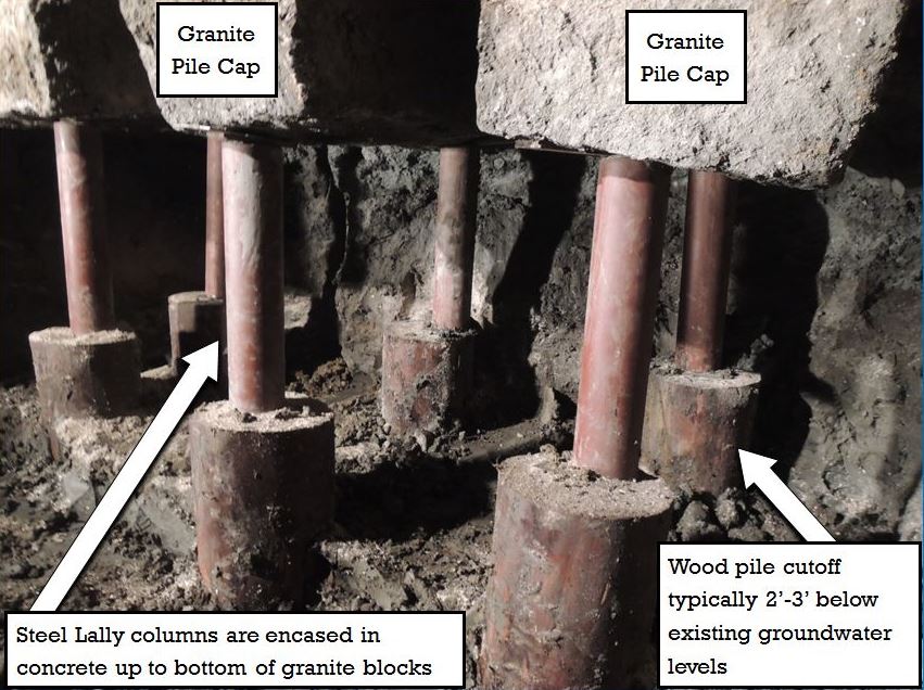
CLICK TO ENLARGE
Groundwater Level Variability
The groundwater level data presented apply to each individual observation well. Groundwater levels may, and often do, vary within relatively short distances, being affected by leaking tunnels, pipes and basements; buried impermeable structures/walls; infiltration of precipitation on ground surfaces, or the lack thereof due to buildings or pavements; local dry wells that are periodic recharge sources; and local withdrawals of water by pumping from sumps, dewatering wells, or other drainage systems. The Groundwater Trust, in the presentation of this data, makes no engineering assessment or legal interpretation. Groundwater levels can vary from day-to-day and often rise following heavy rainstorms or prolonged periods of precipitation. No attempt has been made to explain or otherwise interpret the groundwater levels and/or variations herein presented.
The groundwater level data presented apply to each individual observation well. Groundwater levels may, and often do, vary within relatively short distances, being affected by leaking tunnels, pipes and basements; buried impermeable structures/walls; infiltration of precipitation on ground surfaces, or the lack thereof due to buildings or pavements; local dry wells that are periodic recharge sources; and local withdrawals of water by pumping from sumps, dewatering wells, or other drainage systems. The Groundwater Trust, in the presentation of this data, makes no engineering assessment or legal interpretation. Groundwater levels can vary from day-to-day and often rise following heavy rainstorms or prolonged periods of precipitation. No attempt has been made to explain or otherwise interpret the groundwater levels and/or variations herein presented.
DISCLAIMER OF WARRANTIES, TERMS AND LIABILITY
The data and information accessible on this website is provided "as is" and there may be delays, omissions or inaccuracies in such information and data. The Boston Groundwater Trust, its affiliates, agents and information providers cannot and do not guarantee the accuracy, sequence, completeness, timeliness, or fitness for a particular purpose of the information or data made available through this website.
THE BOSTON GROUNDWATER TRUST SHALL NOT BE HELD LIABLE TO ANY PERSON FOR INDIRECT, SPECIAL, PUNITIVE, CONSEQUENTIAL, OR INCIDENTAL LOSS OR DAMAGE. THE BOSTON GROUNDWATER TRUST SHALL NOT BE LIABLE FOR ANY UNAVAILABILITY, INTERRUPTION, DELAY, INCOMPLETENESS, OR INACCURACY OF INFORMATION.
Building Foundation Information
In continuing our efforts to obtain a better understanding of these wood pile cut-off elevations the Boston Groundwater Trust (BGwT) reviews individual building permit jackets at http://www.cityofboston.gov/isd/building/docroom/. Here the user can simply enter their street number, street name, ward, and select the appropriate document type from a drop-down list.
In addition, the BGwT reviewed multiple Building Inspection Reports (BIR’s), located in the Fine Arts Department of the Boston Public Library. These reports contained such useful information as construction dates, architect’s and builder’s names, building descriptions, and, most importantly, woodpile cutoff elevations. The BIR’s are organized in bound volumes and, along with the reports, often contain original drawing and blueprints (usually floor plans). The BGwT researched a total of 145 BIR’s that were produced between 1879-1903. Although 181 volumes originally existed, 36 volumes are missing.
The Great Boston Fire of 1872 (LINK) destroyed the majority of Boston’s commercial district. In that fire many official and private building documents were destroyed. Therefore, no reports, plans, or permits exist in these records from before 1873.
When accessing our information center the following page building parcels with foundation information are shaded. Zoom into close to near block/street level. Simply click on the shaded parcel and the foundation we collected will appear with information in the bottom right-hand corner. The information listed will include the address, foundation type (wood, concrete, or steel), cut-off elevation (if available), and whether or not the building has been underpinned. When viewing this data, it is important to remember that the lower the cut-off elevation number, the better.
Additional building foundation information is added as we continue our research and work with the appropriate parties on obtaining this critical information.
DISCLAIMER OF WARRANTIES, TERMS AND LIABILITY
The Building Foundation Information accessible on this website is provided "as is", and there may be omissions or inaccuracies in such information and data. The information contained in the Building Foundation Information should only be used for reference and not as a definitive measuring guide for wood pile cut-off elevations or underpinning information. The Boston Groundwater Trust (BGwT), its affiliates, agents and information providers cannot and do not guarantee the accuracy, sequence, completeness, or fitness for a particular purpose of the information or data made available through this website.
THE BOSTON GROUNDWATER TRUST (BGwT) SHALL NOT BE HELD LIABLE TO ANY PERSON FOR INDIRECT, SPECIAL, PUNITIVE, CONSEQUENTIAL, OR INCIDENTAL LOSS OR DAMAGE. THE BOSTON GROUNDWATER TRUST (BGwT) SHALL NOT BE LIABLE FOR ANY INCOMPLETENESS, OR INACCURACY OF INFORMATION.
I have read and understand the foregoing Disclaimer of Warranties, Terms, and Liability. In order to acknowledge that agreement and access the accompanying information please click the image below: